
Flood Catastrophe Prevention for Ajijic Homebuyers
 By Barbara Harwood
A couple of springs ago, a student named Kevin came bounding into the studio: “I think I’ve found a site for my shelter. Can you look?”
One of our duties as Adjunct Professors at the Frank Lloyd Wright School of Architecture is to assist the students in designing and building a desert shelter in which they will live during their winters at Taliesin West in Scottsdale, Arizona.
“Sure,” I replied,” heading out onto the desert path that led to his newly chosen site.
“Look,” he said, using his hands to show me how the shelter would be set onto the site, “I’ll have the south open to the sun here so it can keep me warm in winter, and I’ll put up a stone wall here on the north to protect me from the winds . . . “
As he continued, I could see his mastery of the concepts of passive solar heating and natural cooling.
But he had missed something vital. “Kevin,” I asked, “What do you see on the northwest edge of your site?”
“A dry channel . . . like maybe an old creek bed?”
“Right,” I said. “Now look northeast. What do you see there?”
“Another dry creek bed?” he answered.
“Right, and where do these two dry creek beds meet?” I asked.
The light was beginning to dawn. “Oh, right in front of my site.”
“So,” I said, “in Arizona these dry creek beds, or arroyos, look dry and useless in the dry season. But if we should have a heavy rain, what do you think would happen here?”
“Well, I guess water would run down both of these and they would join right here, and if it got too deep, I guess I would get pretty wet,” he said.
“Right. So what does this mean for the site you have chosen?” I asked.
“I think it means that if there is a big rain I might be in serious trouble – like I might be washed away or even drown.”
BINGO!
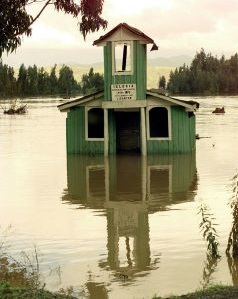
I remembered this scene with Kevin when I saw the photos of the catastrophic damage to a small house on the Racquet Club entry road after the mammoth five inch rainstorm we had in 2007. I had noticed in previous weeks, as we drove up to the Club, that this lovely home was in what might have been the prettiest site in the area. A lovely tree-lined arroyo framed its eastern border. Just north was a small depression where water flowed over the edge. It must be beautiful in spring, I thought, to have a natural little waterfall in your backyard.
But how safe was it, I wondered. What could happen if there were a big rainstorm? Had someone done a flood plain analysis? Of course not. This is Mexico. Had they even looked carefully at the location – the stark junction between an old streambed and a major road - and applied common sense?
Actually, I’m guessing it probably never occurred to them. They no doubt have returned to look in horror at the magnificent mess their wrecked, mud-sodden house has become as the arroyo filled a thousand feet above and came roaring down to the once peaceful little waterfall behind their house, dumping its hundreds of thousands of gallons at eight-pounds per gallon and rolling rocks straight onto their house, their yard, and both of their cars.
Further, I’m sure that when people go out to look at houses on newly-leveled hillsides that have been denuded of protective tree-cover, they never think about the consequences of the kinds of storms that produce massive rainfall and landslides. Nobody mentions it because the realtors or owners hoping to make a sale know it might interfere, so the buyers aren’t warned. They never contemplate the fact that if these cut-open hillsides are saturated and slide, their new house could end up on the street below with a new address. Or worse, it could end up a pile of bricks and mortar in chunks floating on a river of mud down to the lake.
Or, worst of all, the detritus of their damaged houses, the mud from their newly leveled sites, could wind up wiping out the homes of hundreds of very poor families who live below them. This is exactly what happened to the village of San Juan Cosala September 13, 2007. The town was buried in mud that rushed down the mountainside from the Racquet Club where developers had been allowed to divert natural arroyos and slice open vulnerable hillsides at will. During the horrendous storm, those arroyos returned to their natural home – the Path of Least Resistance - and it was a complete miracle that no lives were lost. Even more recently, on August 11, 2010, in Atotonilquillo and nearby villages in the Municipio de Chapala, an early-morning cloudburst produced a torrent that sent a thousand people fleeing from their homes.
What should be done about this?
First, we can educate ourselves by becoming aware of danger when we see it. An arroyo that dead-ends at the top of a group of houses? Red Flag! A stream that has been diverted, and rerouted, even if it is channelized, potential danger exists when heavy rains push it back into its original flow patterns
A house cut into a steep hillside? Risky in this wet tropical climate zone with uncompacted, high-aggregate content soil (big rocks mixed with smaller rocks without adequate soil to hold them together).
A home set on a relatively flat plain, but with a major arroyo cut into a steep mountain behind it – even if it is several hundred yards up – and running down beside the house. That house is probably on an unregistered flood plain. We must open our eyes and think about the implications of rainwater flowing downhill in the path of least resistance!
Second, we are in Mexico where rumor has it that the greased palm can wipe out any regulation that interferes with a developer’s desires. The people who live here must demand that protective land planning regulations remain in effect and are enforced where human lives are at risk. We must demand that steep hillsides retain their tree cover, that adequate planning for drainage is presented at the time of preliminary project plan review, and that before final plan approval, adequate drainage is guaranteed by the developer, drainage that will also be guaranteed not to cause loss and grief to those who live below.
Third, realtors can tell developers who denude hillsides and divert arroyos that they will not sell their homes to unsuspecting buyers.
Fourth, we current residents of this area are not without other ways of assuring our safety and that of our friends who are future homebuyers. We can boycott realtors who refuse to tell the truth about developers who are less than honest in applying safety regulations for their subdivisions. We can steer our friends away from developments with homes set on dirt shelves denuded of trees and brush, particularly if they are below a steep mountainside which has been cut to provide development space. We can point out streams or arroyos in the hills behind houses and caution people to ask questions about where water flows in heavy rains.
In short, we can teach them what we learned from the tragedy of September 13, 2007, at San Joan Cosala and the Racquet Club. If we don’t, then we, ourselves, will be guilty the next time a waterspout washes away a house – and it could be the home of a friend.
Kevin didn’t build his shelter on that protuberance between two arroyos. And it was a good thing. The next spring, Taliesin West had record rainfalls. That arroyo turned into a mighty river two subsequent nights. At the very least, he would have been wet and homeless. At the worst . . . well, let’s just say I’m glad he asked before he built it.
 Editor
Reader Comments